
Cruach na Miol [Croaghnameal]
Good walks are even better shared.
Overview
Cruach na Miol [Croaghnameal]
Overview
Nestled in the picturesque landscape of western Ireland, Cruach na Miol, or Croaghnameal as it's also known, stands as a welcoming peak for hikers seeking both challenge and beauty. With an elevation of 625 meters, it's considered a Marilyn, offering an exhilarating experience to those who venture to its summit.
Geology
Cruach na Miol is primarily composed of Old Red Sandstone, a treasure trove of geological history. It presents an enticing tapestry of rugged formations that any geology enthusiast would appreciate. The erosion over countless years has played its part beautifully, producing unique landforms that enhance the area's visual appeal.
Routes
There are multiple routes to reach the summit, catering to different levels of experience.
- The Keenagh to Cruach na Miol route is a moderate hike that begins in Keenagh, taking you through diverse terrains including heather fields, providing a delightful experience for those looking to push their limits without going overboard. Roughly 7.0 km long, it typically takes about 3.5 hours to complete.
- Alternatively, the Tullycross Trail offers a more leisurely experience. This route presents a gentle climb and picturesque surroundings, perfect for families or those who prefer to take their time soaking in the sights. At about 5.5 km, it can feasibly be completed in 2.5 hours.
Summit Features
Upon reaching the summit, you'll be greeted by a sizable stone cairn - an obligatory photo op awaiting you! The wide-open space around the summit is perfect for a pit stop, where you can relish your snacks whilst surveying the stunning overhead views.
Terrain
Hikers can expect a delightful mix of grassy slopes peppered with rocky outcrops. The terrain, while generally manageable, can involve some tricky bits, especially if the weather has been less than cooperative.
Views
The top offers breathtaking panoramic views that sweep across the mountains and down to the distant coast, providing a visual feast that's worth every step of the climb. Late spring to early autumn is the best time for hiking, ensuring that the views are unobstructed and the weather is generally kinder.
Hazards
As with most mountain hikes, be prepared for Mother Nature’s cheeky mood swings; weather can change swiftly. Loose stones and wet patches can sneak up on you, so a good pair of sturdy boots is recommended.
Access
Accessing Cruach na Miol is convenient. The nearest parking can be found in the village of Tullycross, accommodating about 15 vehicles. Public transport options include a bus service from Westport to Letterfrack, followed by a scenic walk to Tullycross.
Facilities
After conquering Cruach na Miol, tasty treats and some much-needed refreshment await you back in Letterfrack, where several cafes and restaurants are eager to serve hungry hikers. Public toilets are also available in this charming village.
History
The name Cruach na Miol, meaning 'Mound of the Pigs', hints at the area's agrarian past and its ties to livestock. The mountain stands as a silent witness to folklore and traditions that have woven themselves into the local culture over generations.
In summary, whether you are looking for a strenuous hike or a leisurely saunter, Cruach na Miol offers a slice of natural beauty that you won’t want to miss. So pack your boots and bring along your sense of adventure – the mountain awaits!
Explore routes near Cruach na Miol [Croaghnameal]
Public walks starting within 80 km of this hill. Nearby does not mean a route reaches the summit; check its map and access before setting out.
Florence Court: Riverside and Forest Circuit, County Fermanagh
View route
Derry~Londonderry City Walls Circuit
View route
Banagher Glen and Forest: complete higher-return circuit
View route
Route planning notes
These notes describe possible approaches, not verified navigable routes or permission to cross land. Check current paths, local access rules and conditions before setting out.
Keenagh to Cruach na Miol
This moderate route begins in Keenagh village and offers an engaging hike through heather and grass, culminating in stunning panoramic views from the summit.
Tullycross Trail
A scenic circuit trail that starts and ends in Tullycross. This route features a gentle ascent and provides a leisurely pace surrounded by breathtaking flora.
Make a day of it, together
Find someone to share the walk with, or organise a day out along a route you like.
Hill facts and local notes
Classifications
Elevation
438m
1,437 ft
Prominence
146m
Coordinates
54.6618, -7.9434
H037793
OS Map
11
At the Summit
At the summit, hikers will find a large stone cairn which serves as a perfect lunch spot while soaking in the sublime views across the surrounding countryside.
Terrain & Geology
The area is primarily composed of Old Red Sandstone, giving the mountain its rugged formation and distinct reddish hue. Erosion has sculpted many features, providing unique textures and shapes to the landscape.
Views & Scenery
From the summit, one can enjoy sweeping vistas of the surrounding mountains and the distant coast, as well as the tranquil beauty of the nearby lakes.
History & Heritage
Name Origin
The name 'Cruach na Miol' translates to 'Mound of the Pigs', suggesting a historical association with livestock in the area.
Historical Significance
The mountain holds cultural importance in local folklore and traditional stories surrounding the region, showcasing the deep connection between the landscape and its inhabitants.
Getting There & Facilities
Check current local access restrictions, parking rules and transport timetables before travelling. These notes do not confirm public access to the summit.
Parking
Parking is available in the village of Tullycross, with space for approximately 15 vehicles.
Public Transport
The nearest bus service is available from Westport to Letterfrack, followed by a modest walk to Tullycross.
Nearby Facilities
In Letterfrack, there are several cafes and restaurants where you can refuel post-hike, along with public toilets.
Safety Information
Known Hazards
- Watch for sudden weather changes, as conditions can shift rapidly in mountain areas. Also, be cautious of loose stones and slippery patches, particularly in wetter months.
General Safety Tips
- Check weather conditions before setting out
- Carry appropriate clothing and equipment
- Let someone know your planned route
- Take a map, compass, and GPS device
- Carry emergency supplies: food, water, first aid kit, torch
Hills
Some common questions about the hills answered
Are there group walks up Cruach na Miol [Croaghnameal]?
Many walkers use Walkmates to join or organise walks with others. You can check for group walks around Cruach na Miol [Croaghnameal] through the maps
Are there other walkers around Cruach na Miol [Croaghnameal]?
Activity varies by location and time, but Walkmates lets you see whether others have shared walks or shown interest in this area. Find other people through the walking friends search walking friends for Cruach na Miol [Croaghnameal] search or of course create your own walk for Cruach na Miol [Croaghnameal]
Can I organise a walk to Cruach na Miol [Croaghnameal]?
Yes. If there aren’t any walks listed already, you can create a walk and make it available for others to join.
If you're signed up to Walkmates, you can create a walk to Cruach na Miol [Croaghnameal].
How do I find a walk up this hill?
There are often multiple ways to walk this hill, depending on experience and route preference. Walkmates helps you explore walks and routes that others have shared.
Can I suggest a new route up Cruach na Miol [Croaghnameal]?
Yes. You can suggest or create routes to share with others. Walkmates focuses on the social side of walking, so routes are used to help people organise walks and explore areas together, rather than as detailed navigation tools or route libraries.
Other uses really appreciate knowledgeable walkers sharing their routes. Share your favourite route to Cruach na Miol [Croaghnameal] here
The is an error or something incorrect about this hill. How do I let you know?
We always strive to keep the information on Walkmates as accurate as possible. If you find an error, please let us know through the contact form and we'll aim to correct it as quickly as possible
Community Discussion
Comments
Location
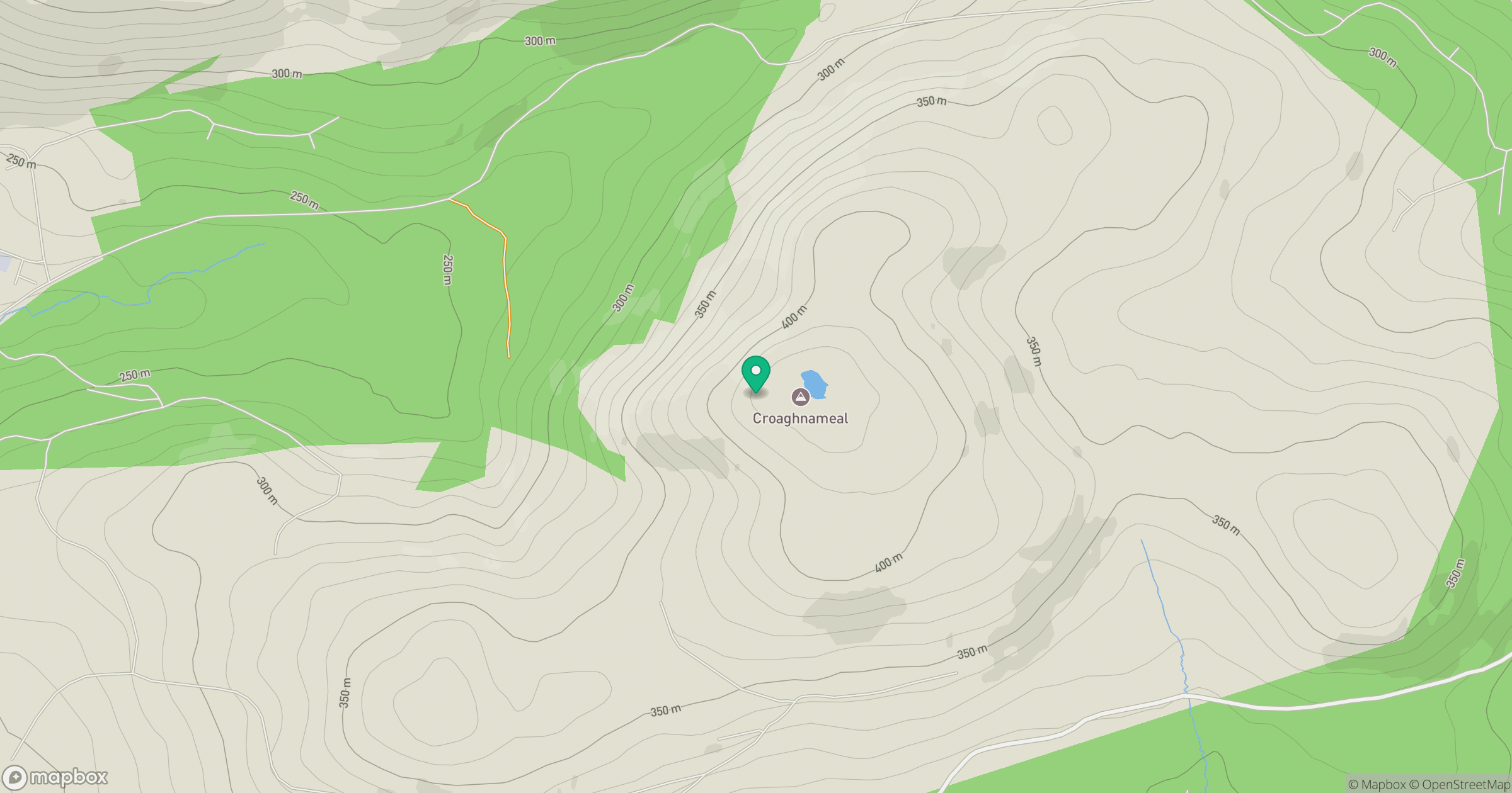
Grid reference: H037793
View on OpenStreetMapOpens a map in a new tab, centred on the hill.
Hills within 30 km
Straight-line distance, not a walking route or confirmation of access.
No comments yet. Be the first.